
Rylock Challenge
- Mar 29, 2026
- Last edition date
- Distances: 2km and 5km
At a glance
- Last edition date
- March 29, 2026
- Distances
- 2 km · 5 km
- Where
- Sea · Tahunanui Beach, Nelson, Tasman, New Zealand
About the race
Tahunanui Beach provides the starting point where swimmers plunge into the sea to trace the coastal contours of Nelson. The Rylock Challenge is an open water sea swimming race held at Tahunanui Beach in Nelson, in the Tasman region of New Zealand. Organized by the Nelson Triathlon & Multisport Club as part of the Nelson Endurance Series, the event takes place in late March at the close of the southern summer season. Swimmers can take on two distinct courses of 2,000 meters and 5,000 meters. The premier 5-kilometer course starts directly from the sand at Tahunanui Beach, heads north along the shoreline, loops around Haulashore Island, and returns to the beach.
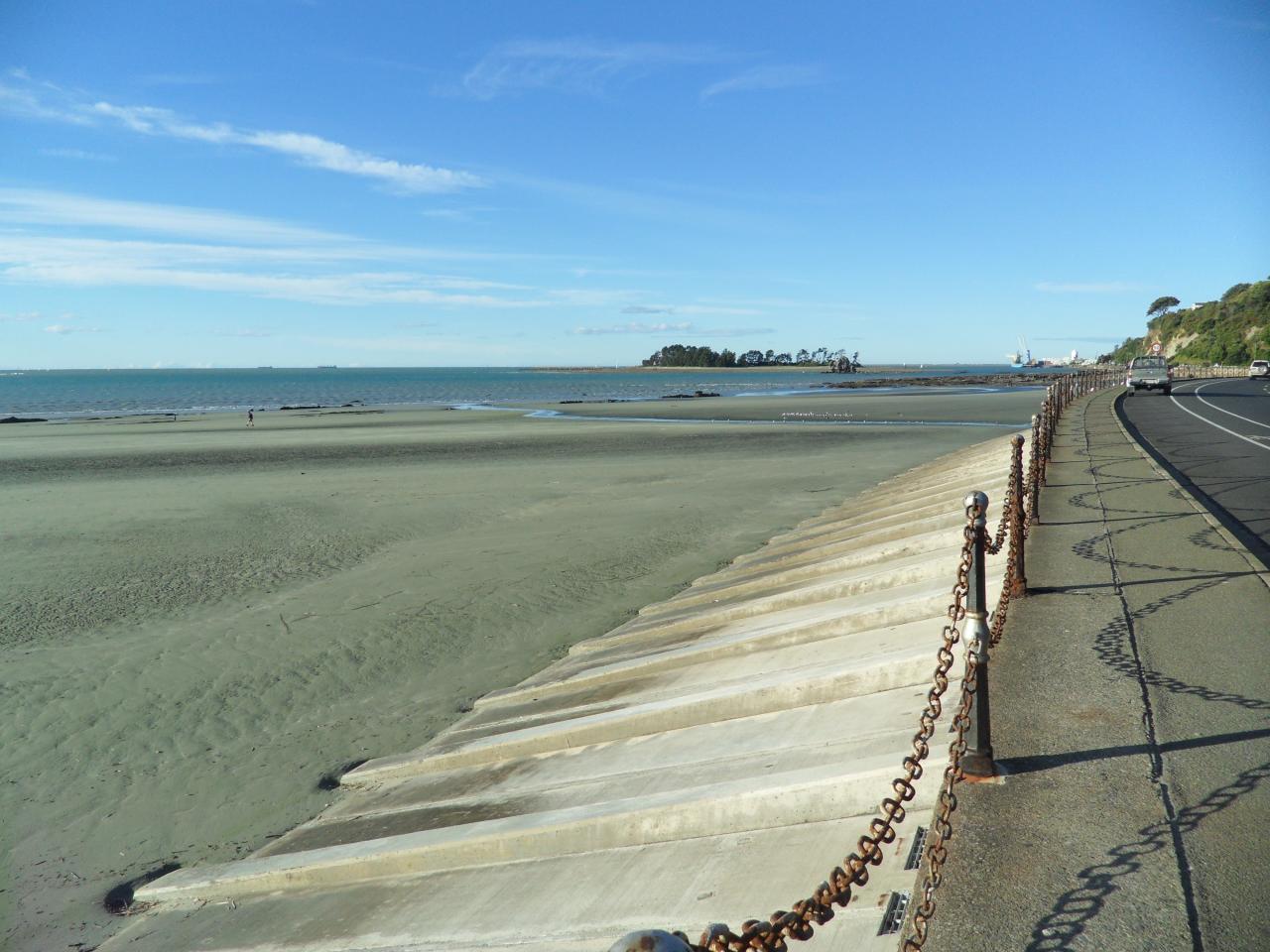
Completing the loop demands strong pacing and an understanding of coastal water movements. In past races over a 1,200-meter course, swimmers encountered a tide-assisted first leg, a challenging middle section with a cross-current, and a final leg pushing against the tide. Across a 750-meter distance, competitors experienced a lightning dash to the first mark followed by a side current and a final slog to the finish. Reading the tidal currents along the shore is essential to staying on course before making the turn.
Fifeshire Rock and the shipwrecks of the harbor narrows
Arrow Rock is a small island located in Tasman Bay off the coast of Nelson. A narrow channel exists between Arrow Rock and Haulashore Island, creating a tight sea passage between the two landforms. The rock was named after the 212-ton brig Arrow, which made history when it became the first ship to sail into Nelson harbour on November 2, 1841. The barque Fifeshire was wrecked on Arrow Rock on February 27, 1842, leading the rock to be subsequently renamed Fifeshire Rock. Maritime misfortune struck again on September 15, 1866, when the schooner Three Sisters was wrecked after hitting Arrow Rock. Today, spotted shags inhabit the craggy ledges of the rock.
Haulashore Island and the Boulder Bank entrance
Immediately across the narrow channel from the shipwreck rocks sits Haulashore Island, the central turning mark for the long-distance swimmers. The entrance to the harbour is protected by a 13-kilometre-long natural bank of rocks called the Boulder Bank, which separates the estuary of Nelson Haven from Tasman Bay. Human engineering reshaped the entrance in 1906, when a cut was made in the Boulder Bank to allow larger vessels to access the port, severing the spit and leaving Haulashore Island standing alone. The resulting island covers an area of 0.5 hectares. In the 1960s, ferrets were introduced to the island to manage its rabbit population. Swimmers round this compact landmass before turning back toward the beach.
Nelson Haven and the shore along Rocks Road
The Tāhunanui slump in 1892 and the subsequent creation of Rocks Road led to the erosion of Tāhunanui beach. On Britannia Heights, a time gun was erected in 1858 at the site where Captain Wakefield had placed a flagpole in 1841. Behind the rocky rampart of the Boulder Bank lies Nelson Haven, an estuary characterized by coastal salt marsh and mudflats. The estuary measures over 8 kilometers in length and reaches a width of up to 2 kilometers. The area is subject to regular tidal cycles that expose and submerge the mudflats. These extensive mudflats provide an ideal habitat for a large population of mud crabs. About four kilometres from the race area, the Maitai River empties into Nelson Haven.
At the river mouth, the estuarine flats host bird species including Red Knot and oyster catchers. The river's catchment area covers approximately 9,000 hectares. Native fish species found in the river include inanga, longfin eel, and brown trout. About four kilometres from the race area lies Waimea Inlet, an arm of Tasman Bay on the northern coast of the South Island. Covering approximately 3,455 hectares, it is the largest estuary in the South Island of New Zealand. The inlet formed over the last 6,000 years due to post-glacial sea level rise and sediment deposition. It contains 10 islands, with Bell Island being the largest at 147 hectares. The tidal movement within Waimea Inlet is immense, with a tidal range between 2.6 and 4.2 meters.
Approximately 95% of the inlet is exposed at low water during spring tides. The estuary serves as a habitat for 31 marine and 11 freshwater fish species. Within the Waimea Inlet sits Best Island, which spans 3.7 kilometres in a northwest to southeast direction. The island is linked to the South Island and Bell Island via causeways, though legal access to properties on the island is restricted to the sea. Moturoa / Rabbit Island was formed approximately 7,000 years ago through the accumulation of barrier islands near the Waimea River mouth. Māori people have occupied the island for more than 800 years. In 1908, the Rabbit Island Recreation Reserve, which includes Rabbit, Rough, and Bird Islands, was established as a public reserve.
The island features a long swimming beach and is connected to the mainland by a causeway spanning a tidal area. The island's beach is characterized by large sand dunes topped with pine trees that have exposed roots. Across a narrow channel, a ferry service connects the wharf at Māpua to Rabbit Island. Back at Tahunanui Beach, swimmers complete their journey across the open sea.
Swimming off Tāhunanui Beach: sandspit and rockpools
On the 1500 m course the Rylock swim series used off Tāhuna Beach, the first mark sits by Rocks Road at about 400 m. After that mark comes a stretch of nearly 700 m toward a buoy by the beach's western sandspit. Swimmers squinting into the sun found it hard to choose between the dark outlines of walkers, support kayakers and the marker buoy. Conditions that Thursday were warm water and flat seas, apart from rocks showing in the low tide. At the eastern end of Tāhunanui Beach, low tide reveals rockpools with small crabs, fish and sea snails.
Course
Starts at Tahunanui Beach, heads north along the shoreline, loops around Haulashore Island, and returns. Features a mix of open-water and protected stretches with views of Tasman Bay and the Richmond Ranges.
How to get there
Rylock Challenge
Frequently asked questions
- When was the last edition of Rylock Challenge?
- The last edition of Rylock Challenge took place on March 29, 2026.
- What distances does Rylock Challenge offer?
- Rylock Challenge offers 2 km and 5 km.
- Where does Rylock Challenge take place?
- Rylock Challenge is a sea swim. Location: Tahunanui Beach, Nelson, Tasman, New Zealand.
Where to stay
Nelson offers a mix of beachfront holiday parks, boutique bed-and-breakfasts near the harbor, and self-contained apartments in the city center. Staying near Tahunanui Beach provides direct access to the start line, while city-center options are within a short drive. Prices typically range from $120 to $350 NZD per night depending on the proximity to the coast and the level of service.
Things to do nearby
The Tasman region is defined by its natural topography. Participants often spend the weekend exploring the nearby Abel Tasman National Park via sea kayak to access secluded coves, or cycling the Great Taste Trail. Local vineyards in the Moutere Hills offer tastings, and the city of Nelson itself hosts a dense concentration of craft galleries and artisan workshops reflecting the creative heritage of the top of the South Island.
Swimmers
Other races by this organiser
- Opening SplashNelson, NZ
- Tata Beach SwimTata Beach, NZ
Similar races


Comments
Transparency: some links on this page (stays, flights, experiences, gear) are affiliate links — if you book or buy through them, Omniathlon may earn a commission from the partner at no extra cost to you. As an Amazon Associate we earn from qualifying purchases.