
MMAD Swim
- Jan 26, 2027
- Distances from 200m to 5km
At a glance
- Next edition date
- January 26, 2027
- Distances
- 200 m · 400 m · 1.2 km · 5 km
- Where
- Sea · Mt Martha Beach, Mt Martha, Victoria, Australia
- Entry fee
- 200 m: 40 AUD · 400 m: 40 AUD · 1.2 km: 60 AUD · 5 km: 75 AUD
- Registration
- mmadswim.com.au
About the race
Mount Martha Beach curves for two kilometres of dark yellow sand between two steep cliff headlands on Port Phillip Bay. Here in Victoria, swimmers gather for the MMAD Swim, an open water swimming event held in the bay's protected saltwater basin. Known formally as the Mount Martha Annual Diamond Swim, the gathering has been hosted by the Mount Martha Life Saving Club since 1997. As a longstanding fixture of the Great Victorian Swim Series, it brings together seasoned long-distance competitors, club members, and families looking for a day on the beach. The event program spans five distinct race distances designed for varying experience levels: 200 metres, 400 metres, 1.2 kilometres, 2.5 kilometres, and 5 kilometres.

For those who prefer to share the open water, the 1.2-kilometre event includes a dedicated category allowing participants to swim alongside a friend, a family member, or an entire team. Swimmers across all courses are watched over by a comprehensive rescue fleet staffed by more than sixty water safety personnel. Out on the bay, the setting typically offers remarkably calm and clear water, shielding the pack from open ocean swells and offering scenic views of cliff-top mansions that line the surrounding headlands. In the 5-kilometre event, the multi-lap triangular course can produce an energetic and chaotic start, with competitors thrashing through the foam and zig-zagging to establish position on the run to the opening turn buoy.
Navigating the course demands steady focus, as glare and distance can turn the return leg into a navigational challenge where spotting shore markers requires patience. The popular 1.2-kilometre race can feel similarly crowded, funnelling swimmers into a dense marine stream that mirrors traffic merging onto a highway. When you complete the final circuit and make your break for the beach, the finish line requires careful footing to scramble up the steep slope of the sandy shoreline.
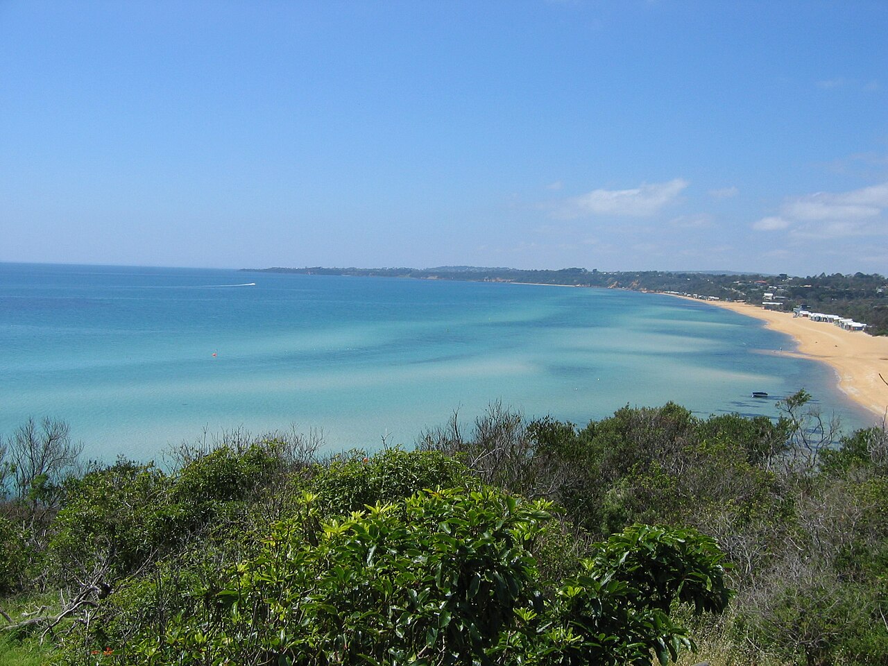
The MMAD Swim course and field at Mount Martha
Courses at the MMAD Swim are marked with buoys, and Mount Martha Life Saving Club members patrol the water to keep swimmers heading in the right direction. The 200 m, 400 m and 1.2 km events are single-lap courses, while the 5 km is swum over two laps. The 1.2 km main event draws a wide field, with ages spanning up to 75 years old. In the 1.2 km swim, medals go to the first, second and third male and female finishers in every age category. Swimmers are expected to finish in less than 40 minutes and to be able to swim 1.5 to 2 km regularly in a pool or in the ocean. A wetsuit is not essential at the MMAD Swim, but many participants wear one for warmth and comfort.
Port Phillip Bay: sheltered waters behind granite cliffs
The peninsula that shapes the bay was formed when rising seas flooded the lowlands of Port Phillip approximately 10,000 BCE. Along the exposed ocean coast between Cape Schanck and Point Nepean, about ten kilometres from Mount Martha, the shoreline faces open-sea surf beaches that are notorious for dangerous swimming conditions. By contrast, Mount Martha Beach sits well tucked inside the protected inland indentation of the bay, where the water is sheltered from rough swells and provides a safe and tranquil venue for open water racing.
Arthurs Seat and Anthony's Nose on the bay
The prominent coastal heights were named Arthurs Seat in February 1802 by Acting Lieutenant John Murray, who observed in their outline a strong resemblance to the famous hill in Edinburgh. On 27 April 1802, British navigator Captain Matthew Flinders landed his crew on the beach directly below the site where the Heronswood estate stands today, about eleven kilometres from the swim area. That same day, Flinders climbed the 314-metre summit of the hill to establish an observation station and survey the wide expanse of Port Phillip Bay. In 1803, early European efforts to occupy the region began at Sullivan's Bay, roughly ten kilometres away, where a short-lived penal colony was founded as the first European settlement in Victoria.
Where the slopes of Arthurs Seat tumble steeply into the saltwater, they form the rocky escarpment known as Anthony's Nose, situated on the southern shore of Port Phillip Bay about eleven kilometres from the race start. For generations, the Boonwurrung Aboriginal people and early colonial settlers conducted fishing expeditions from the rocks of this promontory. In the nineteenth century, rounding the point by land was an unpredictable endeavour, as submerged rocks meant travellers had to wade through the water at high tide, and in 1845 travellers sometimes had to wait for the tide to recede before they could pass. That historic shoreline hurdle was finally subdued when a seawall was built around the headland in 1940.
McCrae Lighthouse and maritime settlement along the shore
Twelve kilometres down the bay from Mount Martha, the McCrae family established McCrae Homestead on a sandy terrace two hundred yards from the beach, overlooking Port Phillip. The surrounding shore was historically fringed by a dense coastal belt of honeysuckle wattles, tea trees, and she-oaks. Building the homestead in this remote location required stringybark timber brought down from the mountain top, as well as three thousand bricks carried across the bay from Williamstown aboard the sailing boat Jemima. Even the family's Broadwood piano made the sea crossing, though it was dropped into the saltwater during transport and remained notoriously difficult to tune ever after. Nearby, McCrae Lighthouse served as the highest light in Port Phillip Bay during its operational life, casting a beam visible from up to 13 nautical miles. Working alongside the South Channel Pile Light, the iron beacon provided vital channel-centre guidance for ships entering Port Phillip Bay.
Mount Martha: cliff estates, Balcombe Creek and boardwalk
The residential landscape overlooking Mount Martha Beach began taking shape in 1889, when a commercial syndicate founded the Mount Martha Company and purchased 504 hectares of seaside land. The estate was planned with roadways following the natural contours of the hillside, ensuring allotments offered expansive views of the water. Across this area, H. Byron Moore introduced the heath Erica baccans to the native bushland. Historic properties such as The Chalet were designed with their main entrance facades oriented directly toward the sea, nestled amid picturesque bushland grounds planted with mature Monterey pines. Farther along the coast, about four kilometres away on the traditional lands of the Bunurong people, Joseph Harris had acquired a large waterfront property south of Mornington township back in 1876, in an area known as Schnapper Point until 1964.
About five kilometres along the coast, Mount Martha House was constructed in 1889 as a seaside hotel designed to draw visitors to the Mornington Peninsula. The original hotel grounds featured two large wells at the rear and a natural spring to the south, while a windmill was installed near the beach, though the water it drew was brackish. The hotel was surrounded by exotic trees including Golden cypress and Monterey pines. Decades later, during World War II, the nearby Balcombe Army Camp served as a major training and rehabilitation base accommodating up to 30,000 United States military personnel. After drying off, the shoreline offers plenty of scenic options to explore.
Hikers can venture inland along the five-kilometre boardwalk that winds beside the Balcombe Creek estuary, connecting Mount Martha Beach to the historic grounds of The Briars. Above the sand on the Esplanade, the South Beach Project café offers outdoor seating and live music, making it the natural place for swimmers to gather and refuel.
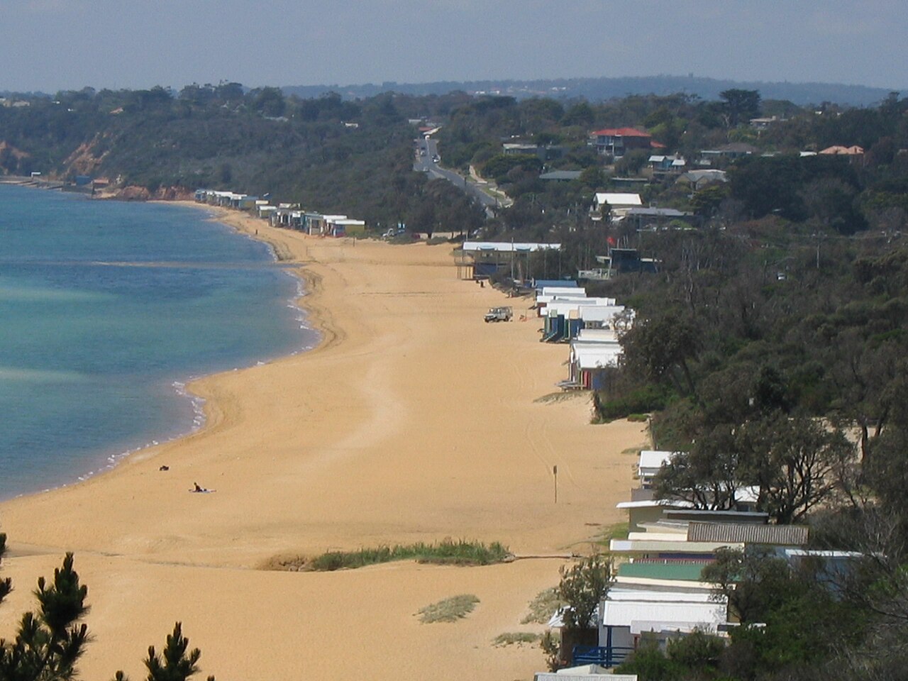
Sources: Mount Martha House
Course
Nipper Swim for young ocean adventurers.
Novice Swim course.
Signature Classic Swim, featuring a category for swimming with friends, family, or teams.
Endurance Challenge.
Previous editions
Since 1997
- 2026results
How to get there
MMAD Swim
Frequently asked questions
- When is MMAD Swim?
- MMAD Swim takes place on January 26, 2027.
- What distances does MMAD Swim offer?
- MMAD Swim offers 200 m, 400 m, 1.2 km, and 5 km.
- How much is the entry fee for MMAD Swim?
- Entry fees by distance: 200 m: 40 AUD · 400 m: 40 AUD · 1.2 km: 60 AUD · 5 km: 75 AUD. Entries are not open yet.
- Where does MMAD Swim take place?
- MMAD Swim is a sea swim. Location: Mt Martha Beach, Mt Martha, Victoria, Australia.
- How do I register for MMAD Swim?
- The reference page for registering for MMAD Swim is http://www.mmadswim.com.au.
Where to stay
Mount Martha offers a relaxed range of stays, from classic 1950s-era beach shacks and modern apartments near the esplanade to boutique bed-and-breakfasts tucked into the hills. During the peak summer period surrounding the race, expect to pay between $250 and $450 per night for a standard holiday rental. Camping options are available in nearby coastal parks, though these require early booking during the January holiday season.
Things to do nearby
Beyond the race, the Mornington Peninsula is defined by its cool-climate wineries and local produce. You can spend the afternoon exploring the walking trails at Point Nepean or take a short drive to the Peninsula Hot Springs. Water-based activities like kayaking and stand-up paddleboarding are common in the sheltered coves, and the local villages feature galleries and boutiques that highlight the region's artistic heritage.
Swimmers
Similar races


Comments
Transparency: some links on this page (stays, flights, experiences, gear) are affiliate links — if you book or buy through them, Omniathlon may earn a commission from the partner at no extra cost to you. As an Amazon Associate we earn from qualifying purchases.