
The Old Harry Swim Challenge
- Jun 19, 2027
- Distances: 2.5km and 5km
At a glance
- Next edition date
- June 19, 2027
- Distances
- 2.5 km · 5 km
- Where
- Sea · Old Harry Rocks, Studland Bay, Studland, Dorset, United Kingdom
- Entry fee
- 69 GBP
- Registration
- wildswimevents.com
About the race
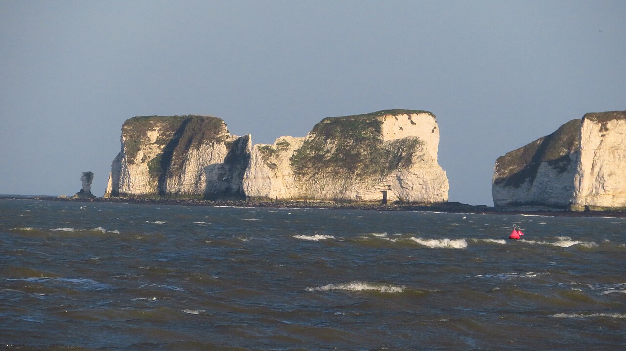
White chalk stacks, caves, and arches stand at Handfast Point, where the Jurassic Coast meets the open sea. Here in Dorset, the Old Harry Swim Challenge is an open water swimming race held in the sea of Studland Bay, taking swimmers out towards Old Harry Rocks near Studland. Setting out from the golden sand of Knoll Beach, competitors choose between two sea courses measuring 2,500 metres and 5,000 metres. Swimmers taking on the 5 km event depart together in a single wave, navigating straight across the open water to the base of Old Harry Rocks before turning around to complete the return leg back to the beach. The 2.5 km challenge provides a distinctive course designed around local coastal currents, offering a tidal-assisted swim from Knoll Beach directly to Old Harry Rocks.
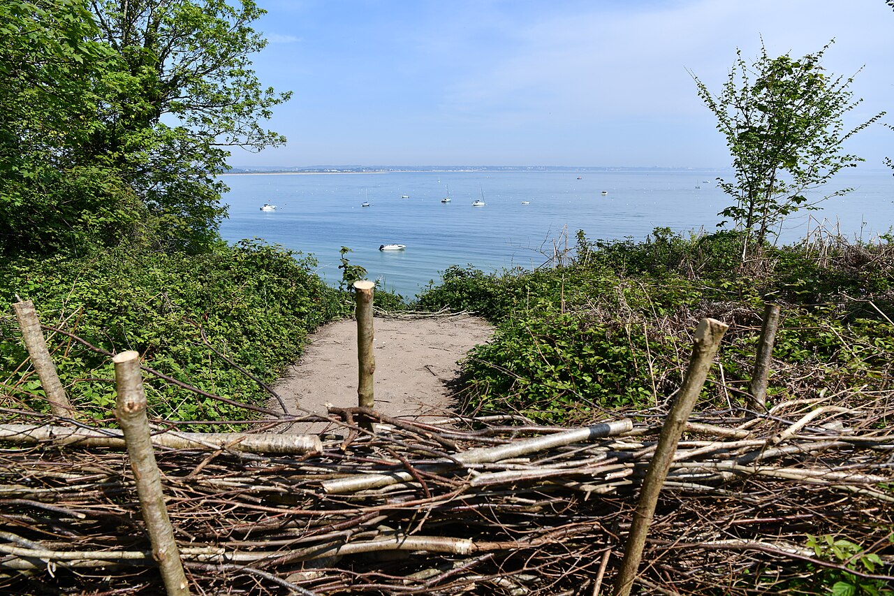
After arriving beneath the chalk cliffs, participants finish their swim and step aboard an awaiting powerboat for a ride across the water back to the shore. Organized by Wild Swim, the challenge takes place in June, making the most of early summer coastal conditions along this stretch.
Handfast Point: 65 million years of chalk and sea
Geologically, Old Harry Rocks form part of Ballard Down, a formation created between 84 and 72 million years ago during the Campanian age of the Late Cretaceous. Over tens of millions of years, the accumulation of coccoliths—microscopic skeletal remains shed by ancient marine algae—gradually built up the chalk headlands 66 million years ago. As geological forces shaped the coastline 65 million years ago, this thick bed of compressed white sediment became the foundation for the stacks, caves, and arches seen today. The continuous hydraulic action of the sea hollowed out deep marine caves and sculpted coastal arches into the chalk face, which eventually weakened and collapsed into freestanding sea stacks.
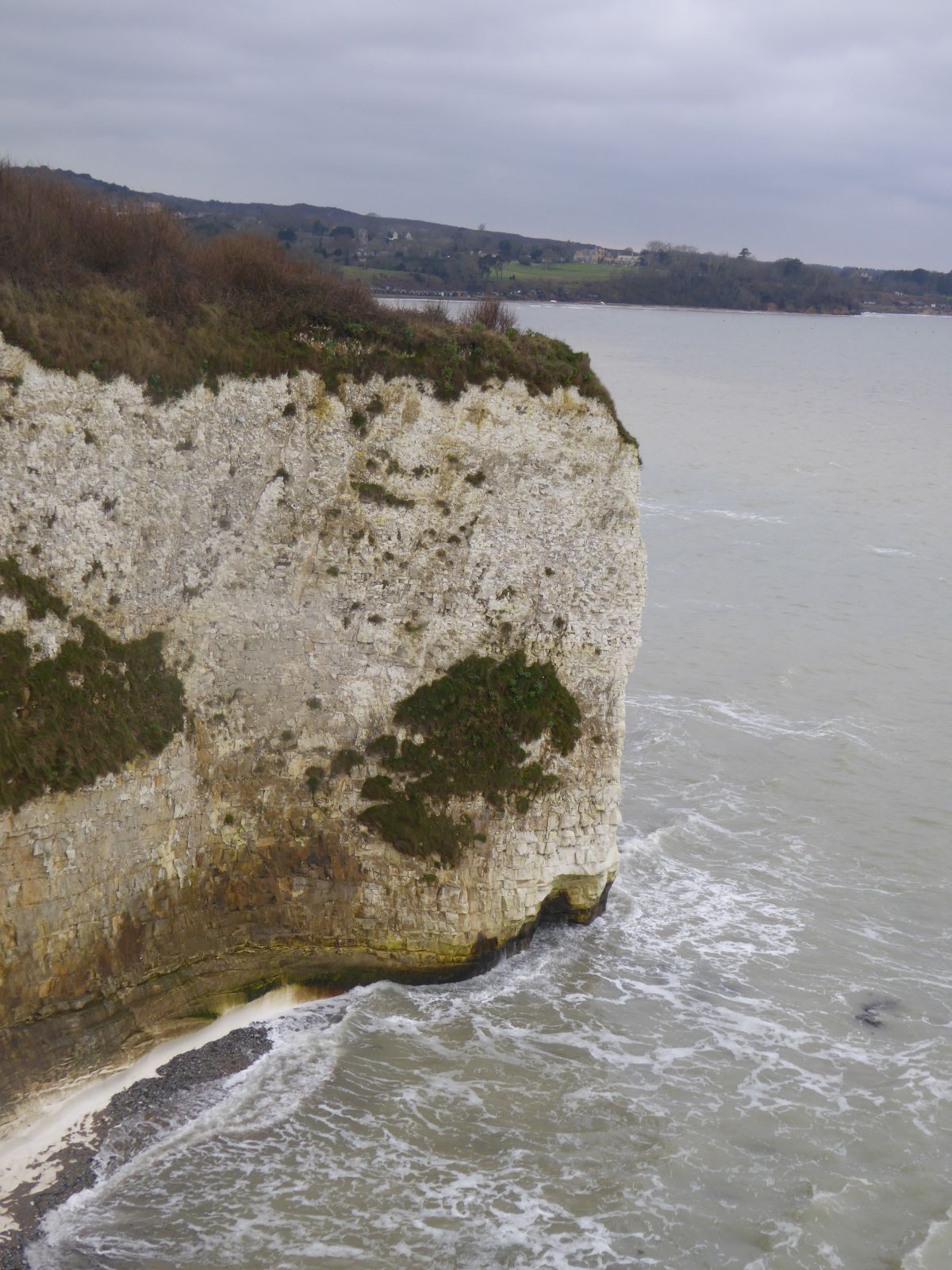
Ballard Down was not always an isolated coastal promontory: only a few thousand years ago, it formed a continuous chalk ridge linked directly across the water to the Needles on the Isle of Wight. Rising sea levels eventually breached this ancient land bridge between 7,000 and 10,000 years ago, leaving isolated white pillars standing out in the sea. Natural erosion continues to reshape the headland across the centuries, as seen in 1509 when the original chalk stack known as Old Harry's Wife collapsed beneath the waves.
Parson's Barn and the Pinnacles: caves, bells and privateers
One traditional story claims that Old Harry—a long-standing euphemism for the Devil—once slept on the rocks, while another legend tells of an ancient Viking named Earl Harold who was transformed into a towering pillar of chalk. A widely repeated maritime tale links the stacks to the 14th-century pirate Harry Paye, who used the rocks to hide his ship from view while waiting to ambush passing merchant vessels along the coast. Just below the chalk cliffs of Ballard Point opens Parson's Barn, an imposing sea-level cavern carved directly into the rock. With an entrance soaring 12 metres in height, the cavern was historically used by local smugglers seeking shelter and secluded landings away from coastal authorities.
Coastal erosion has since taken a heavy toll on the cave, causing a substantial section of the cavern roof to collapse into the sea. The destruction left behind a pair of chalk stacks known as the Pinnacles, the tallest of which reaches a height of 33 metres above the water. When strong maritime winds blow through the natural arches and hollowed crevices around the headland, the rushing air creates resonance resembling the ringing of bells. Local lore explains this acoustic phenomenon with a tale of an ill-fated ship carrying church bells, said to have foundered and sunk off the point as a consequence of the crew's blasphemy.
Studland to Portland: seagrass nurseries and seahorse havens
Beneath the surface, the marine ecosystem surrounding the base of the stacks is protected as part of the Studland to Portland Special Area of Conservation. Across the subtidal areas of Studland Bay lie expansive beds of marine seagrass that form a vital underwater ecosystem. These dense meadows of green blades serve as essential breeding and nursery grounds for commercial fish and create a sheltered sanctuary for seahorses. Swimming through the bay offers a rare perspective over a seabed defined by these protected seagrass habitats. Around Durlston Bay, located just south of the resort of Swanage, coastal cliffs expose Lower Cretaceous strata that have yielded fossil discoveries since Samuel Beckles first uncovered fragments here in the 1850s.
Further along the headlands, Portland limestone and Purbeck beds stretch continuously from Durlston Head to St. Aldhelm's Head, defining the rugged profile of the Jurassic Coast. On the promontory of Anvil Point, established in 1881 to guide mariners along these rocky shores, the Anvil Point Lighthouse overlooks the open channel. These sea-facing cliffs were historically quarried over the centuries at sites such as Dancing Ledge, Seacombe, Winspit, and Tilly Whim Caves. At Tilly Whim Caves, stone quarriers extracted Purbeck limestone horizontally directly from the cliff face during the eighteenth century. The finished stone blocks were lowered from cliff ledges straight onto waiting boats to be carried to Swanage Quay or loaded onto sailing ketches anchored offshore.
This durable Purbeck stone was transported along the coast to build fortifications during the Napoleonic wars, until quarry operations ceased permanently in 1812. The caves were eventually closed to the public in 1976 because of the ongoing danger of rock falls from the unstable cliffs.
Knoll Beach and Studland Bay: dunes, heath and shoreline living
Back in Studland Bay, the shoreline unfolds into a four-mile stretch of golden sand known for its gently shelving bathing waters. The sandy expanse is divided into four distinct beaches: Shell Bay, Knoll Beach, Middle Beach, and South Beach, with a dedicated 900-metre section of Knoll Beach set aside for naturists. Behind the beach lies an extensive dune system that began forming roughly 500 years ago. As these dunes expanded, they formed a natural barrier that cut off incoming sea water, giving birth to Little Sea, a secluded freshwater lake resting just behind the sand ridge. Poole Harbour is a vast drowned valley formed at the end of the last ice age.
The harbour is exceptionally shallow, maintaining an average water depth of just 48 centimetres across its expanse. This vast basin is an internationally recognized wetland on the Ramsar list, safeguarding mud flats, salt marshes, and seagrass meadows. Highlighting the quality of this coastal habitat, ospreys nested in Poole Harbour in 2022, recording the first successful hatching in southern England in 200 years. These waters have carried boats for millennia: in 1964, a 2,000-year-old Iron Age logboat was uncovered off Brownsea Island. Within the harbour waters between Brownsea and Studland lies Stone Island, a ridge of sand and gravel that appears only between high tides. Deeper inside the harbour, near the Arne Peninsula in the southwest, lies Round Island, covering an area of 15 acres.
Only a narrow channel a few feet wide separates Round Island from Long Island, an uninhabited isle whose surface area expands and contracts dramatically with the rising and falling tides. In 1955, potter Guy Sydenham leased Long Island to excavate local clay deposits for his ceramics. On the shores of Studland, the Knoll Beach Café provides both indoor and outdoor seating where swimmers can relax with panoramic views of the water. The estate was historically owned by the Bankes family, who used a local residence in Studland as their private summer home, which now welcomes guests as a hotel.
Old Harry Swim Challenge: cut-offs, wetsuits and weather
The 5 km Old Harry Swim Challenge is gun timed from an in-water start, with wetsuits optional and a cut-off of 3 hours. The shorter 2.5 km option is also gun timed from an in-water start, with a cut-off of 2 hours. Swimmers at the Old Harry Swim Challenge who go without a wetsuit must decide in advance and complete an additional acknowledgement of risk, although the organisers always recommend wearing one. Organisers of the Old Harry Swim Challenge encourage swimmers to tow a float. If the weather is poor on the day of the Old Harry Swim Challenge, the plan is still to go ahead, although the route may change depending on conditions. Studland Bay, where the Old Harry swim begins, is a 2.5 mile (4.0 km) long curved sweep of sandy beaches backed by dunes and heathland.
Course
Timed swim from Studland Beach to Old Harry Rocks, where participants board a boat via a lift and are transported back to shore within 15 minutes.
Swim out from the shore to the iconic Old Harry Rocks, followed by a return swim back to the starting point.
How to get there
The Old Harry Swim Challenge
Frequently asked questions
- When is The Old Harry Swim Challenge?
- The Old Harry Swim Challenge takes place on June 19, 2027.
- What distances does The Old Harry Swim Challenge offer?
- The Old Harry Swim Challenge offers 2.5 km and 5 km.
- How much is the entry fee for The Old Harry Swim Challenge?
- The entry fee is 69 GBP. Price listed is the same for both distances.
- Where does The Old Harry Swim Challenge take place?
- The Old Harry Swim Challenge is a sea swim. Location: Old Harry Rocks, Studland Bay, Studland, Dorset, United Kingdom.
- How do I register for The Old Harry Swim Challenge?
- The reference page for registering for The Old Harry Swim Challenge is https://wildswimevents.com/products/the-old-harry-swim-challenge-2027.
Where to stay
Studland and nearby Swanage offer a mix of traditional stone cottages, converted fishermen’s houses, and boutique hotels overlooking the harbour. During the summer season, expect to pay between 150 GBP and 280 GBP per night for mid-range stays. Camping options are available near the beach, though sites fill quickly during the mid-June window due to the proximity to the coast path.
Things to do nearby
The Purbeck peninsula provides opportunities for sea kayaking around the caves of the headland and SUP sessions in the calmer waters of the bay. For those staying after the race, the area features historical quarrying sites at Dancing Ledge and coastal trekking paths leading to the Anvil Point Lighthouse. Local food experiences focus on fresh seafood landed in the nearby ports.
Swimmers
Other races by this organiser
- Ice Water Swim FestivalCorfe Castle, GB
- The Wild Swimming FestivalSwanage, GB
Similar races


Comments
Transparency: some links on this page (stays, flights, experiences, gear) are affiliate links — if you book or buy through them, Omniathlon may earn a commission from the partner at no extra cost to you. As an Amazon Associate we earn from qualifying purchases.